



Colin Ambler/cvnznews.com
Is your summer going to be a scorcher? Will your town face water restrictions? Are farmers about to battle another dry season? New Zealand has officially entered El Niño, but the real question is simple: how is this going to affect your everyday life?
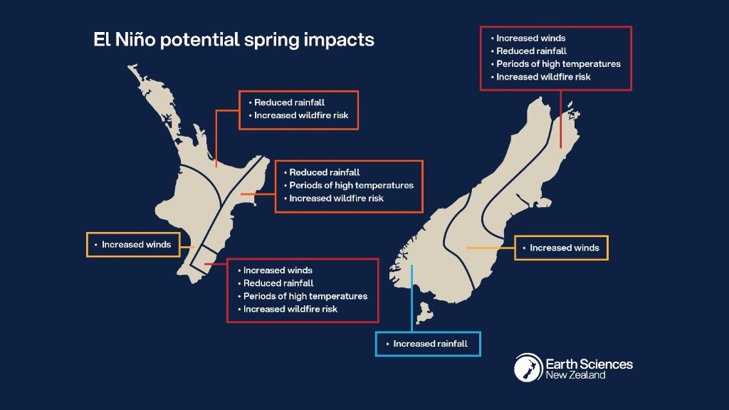
Earth Sciences New Zealand has confirmed that El Niño conditions have formed in the tropical Pacific — and this one is shaping up to be big, potentially one of the strongest on record. In plain language, that means the weather patterns that normally bring balance to our seasons are about to tilt.El Niño usually flips the country’s weather on its side:
- Drier conditions for the north and east — Auckland, Northland, Bay of Plenty, Gisborne, Hawke’s Bay, Wairarapa, Canterbury, Marlborough, eastern Otago.
- Wetter conditions for the south and west — Westland, Fiordland, Southland, and possibly parts of Central Otago.
- Stronger winds across much of the country heading into spring.
This year’s El Niño is already showing signs of being a heavyweight, with ocean temperatures in the Pacific climbing fast — the same pattern seen in the big events of 1972, 1982, 1997 and 2015.
How this could affect you
- Drying soils: Expect crunchy paddocks, thirsty gardens, and higher wildfire risk — especially in eastern regions.
- Water pressure: Lower rainfall means less groundwater recharge. Councils and water‑reliant industries may face tough decisions.
- Windier days: More westerlies mean more drying, more dust, and more unsettled weather.
- Mixed short‑term patterns: Early July may bring a decent rainmaker, but don’t be fooled — the long‑term trend still leans dry for many regions.
- El Niño doesn’t mean disaster — but it does mean change. Stronger winds, shifting rain patterns, and a higher chance of dry spells will shape how New Zealanders garden, farm, travel, and plan through spring and summer.